Western Australia Braces for Monster Storm as East Coast Prepares for a Wintry Snap
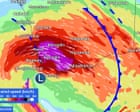
A powerful storm system is set to slam Western Australia’s south-west on Saturday, bringing winds that could rival a category two cyclone, before sweeping east to deliver a sharp cold snap to South Australia, Victoria, and New South Wales early next week.
The Bureau of Meteorology has warned residents from Perth down to Albany to secure loose items and brace for gusts exceeding 125km/h from Saturday evening. The storm, which the bureau’s Daniel Hayes described as “quite significant,” also threatens heavy downpours, flash flooding, dangerous surf, and even a risk of tornadoes.
A deep low-pressure system dragging tropical moisture is driving the conditions. Six-hourly rainfall totals of up to 60mm are predicted for central parts of the region, while the entire south-west coast faces abnormally high tides. Flooding could hit low-lying areas from Sunday morning.
As the system pushes east, South Australia and Victoria’s alpine areas could see warnings by Sunday. By Monday, Melbourne is forecast to experience wind gusts of 50km/h. “It’s going to feel noticeably cool with these strong winds,” Hayes said, adding that alpine regions may see snowfalls early next week. However, the system will lose its tropical moisture as it moves, limiting rain further east.
Despite this wintry blast, the bureau’s long-range outlook suggests the southern two-thirds of the country will see a warmer-than-average winter overall. Meteorologists are also watching the Pacific for a likely El Niño event, which could bring drier conditions to eastern Australia and, combined with global heating, push 2027 toward becoming the hottest year on record.